
How to Reach Chopta Easily: Best Routes, Transport & Travel Tips
Let’s be honest—reaching Chopta isn’t as straightforward as booking a flight to Goa or a train to Shimla. There is no direct train, no airport next door, and if you check Google Maps, the winding red lines might look a little intimidating. But that’s exactly why Chopta remains so unspoiled.
Known as the “Mini Switzerland of India,” this quiet corner of Uttarakhand demands a little effort to reach, but the reward is absolute silence and a front-row seat to the majestic Nanda Devi and Trishul peaks. Whether you are confused about where to change buses (is it Rishikesh or Rudraprayag?), wondering if your hatchback can handle the steep climb to Ukhimath, or just looking for the cheapest way to get there without breaking the bank, I’ve got you covered. In this guide, I’m sharing the exact routes, road realities, and the small mistakes I made so you don’t have to.
You might also like Winter Festival in Mount Abu
Where Is Chopta Located?
Technically speaking, Chopta is located in the Rudraprayag district of Uttarakhand, sitting at an altitude of approximately 2,680 meters (8,790 ft).
But if you are the one behind the wheel or navigating the bus routes, here is what you actually need to know:
Chopta is situated on the Ukhimath-Gopeshwar Road. It connects the Kedarnath valley (Ukhimath side) with the Badrinath valley (Gopeshwar side). Unlike popular hill stations like Mussoorie or Nainital, Chopta isn’t a proper town with a “Mall Road” or a crowded market. It is essentially a stretch of stunning meadows surrounded by the Kedarnath Wildlife Sanctuary.
Distances at a Glance (For Your Planning): If you are starting from major hubs, here is how long the drive really is:
- Delhi to Chopta: ~450 km (12-14 hours)
- Haridwar to Chopta: ~225 km (7-8 hours)
- Rishikesh to Chopta: ~210 km (7 hours)
- Ukhimath to Chopta: ~30 km (1 hour – steep climb)
How to Reach Chopta by Road
Going by road is the most popular way to reach Chopta, simply because the drive along the Alaknanda and Mandakini rivers is beautiful. If you are starting from Delhi, it is a long haul of about 450 km (12–14 hours), so we recommend breaking the journey in Rishikesh or Rudraprayag if you want to stay fresh.
The Best Route:
Delhi → Haridwar → Rishikesh → Devprayag → Rudraprayag → Ukhimath → Chopta
For Bus Travellers
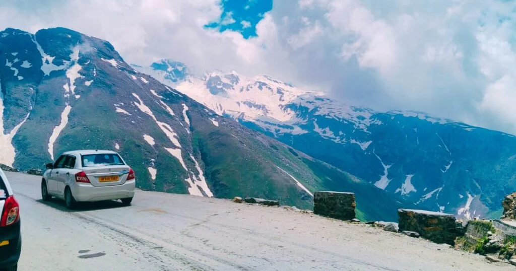
Here is the reality check—there are no direct buses to Chopta. You will need to take a bus from Delhi or Rishikesh to Rudraprayag or Ukhimath. From there, you can hire a private taxi or hop into a shared jeep (sumo) for the final 30–40 km climb. The roads are generally good, but the last stretch from Ukhimath is narrow and curvy, so drive carefully!
How to Reach Chopta by Train
Since Chopta is a high-altitude destination, it does not have a railway station of its own. The train journey only gets you to the foothills; the rest of the trip must be covered by road.
Nearest Railway Stations:
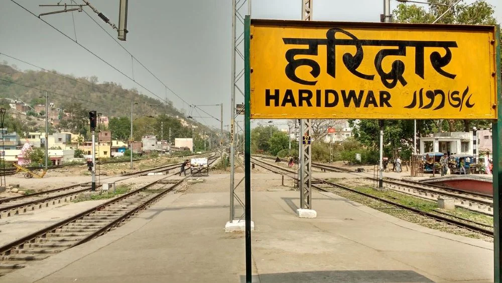
- Haridwar (HW): This is your best option. It is roughly 225 km from Chopta and is very well-connected to major Indian cities like Delhi, Mumbai, and Kolkata.
- Rishikesh (YNRK): Closest to the mountains (~210 km), but it has fewer long-distance train connections compared to Haridwar.
The Onward Journey: Once you deboard at Haridwar or Rishikesh, the drill is the same as the road route.
1. Exit the station and head to the Bus Stand.
2. Look for a bus going to Rudraprayag or Ukhimath (try to catch an early morning bus, around 5:00–7:00 AM).
3. From Ukhimath, hire a local taxi or shared jeep for the final 1-hour climb to Chopta.
How to Reach Chopta by Air
If you are traveling from further away—like Mumbai, Bangalore, or Kolkata—taking the train might eat up too much of your vacation time. In that case, flying is definitely your best bet.
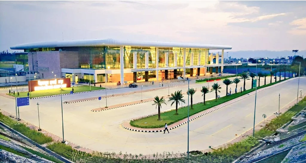
You will need to book a flight to Jolly Grant Airport in Dehradun. It is the closest connection, sitting roughly 220 km away from Chopta.
But here is the thing: Landing at the airport doesn’t mean you have arrived. You still have a fair bit of road travel left—about 7 to 8 hours to be precise.
Once you step out of the airport, you have two real options. You can hire a private taxi directly to Chopta, but be warned—it can get a bit heavy on the pocket (expect to pay anywhere between ₹5,000 to ₹7,000).
If you want to save that money for the trip, I recommend taking a quick cab to Rishikesh first (it’s just a 30-minute drive). From Rishikesh, it is much easier and cheaper to find buses or shared jeeps heading up towards Rudraprayag and Ukhimath.
Local Transport Options in Chopta
Chopta is small. Very small. So don’t expect autos, city buses, or app-based cabs here. Local transport is simple and limited—and that’s part of the charm. Most travellers reach Chopta in a private taxi or their own vehicle, and honestly, that’s the most comfortable option. If you’re coming from nearby towns like Ukhimath or Rudraprayag, you may find shared taxis, but they run only when enough passengers are available. Sometimes you wait. Sometimes longer than expected.
Inside Chopta itself, there’s no need for transport at all. You walk. From your stay to nearby viewpoints. To small cafés. To the starting point of the Tungnath trek. Everything is close, quiet, and slow-paced. During peak season, local drivers are usually around for drop-offs or pickups, but in the off-season, availability can be unpredictable. That’s why it’s always better to plan your return transport in advance. In Chopta, things don’t run on a timetable—they run on mountain time.
Important Stops & Pitstops
1. Devprayag (The Sangam) – About 70 km uphill from Rishikesh, you will hit Devprayag. This isn’t just another town—it is where the Bhagirathi and Alaknanda rivers crash into each other to officially form the Holy Ganga. You don’t need to trek down to the water if you are in a rush; just pull your car over on the highway. You can clearly see the two distinct colors of the rivers merging. It is a sight that stays with you.
2. Srinagar (For a Proper Meal) – After Devprayag, the next big town is Srinagar. This is your best bet for a solid lunch. Once you cross this town, the restaurants get smaller and the menu options shrink. If you are craving a proper North Indian thali or need to stock up on snacks and water bottles, do it here.
3. Dhari Devi Temple – Just a little ahead of Srinagar, keep an eye out for the Dhari Devi temple located right in the middle of the Alaknanda River. Local legends say she is the protector of the Char Dham region. It is a powerful, scenic spot to take a breather and offer a quick prayer for a safe journey.
4. Rudraprayag (The Turning Point) – This is where the road splits—one goes to Kedarnath, the other to Badrinath. It’s also where the Mandakini and Alaknanda rivers meet. It’s a great spot for a final tea break before you start the steeper climb towards Ukhimath.
Best Time to Travel to Chopta
Chopta is a year-round destination, but the “best” time depends entirely on the experience you are chasing. If you want clear views of the Himalayas and an easier trek to Tungnath, visit between April and June. The weather is pleasant, and the roads are completely open.
For snow lovers, December to March turns the valley into a white winter wonderland, though road blockages near the top are common. We also highly recommend visiting in March or April to see the forests bloom with vibrant red Rhododendrons. However, try to avoid the monsoon season (July–August) due to frequent landslides in the region.
Conclusion
Reaching Chopta is not about finding the fastest route—it’s about choosing the one that suits your travel style. Whether you fly part of the way, take a train to the nearest town, or drive through the mountains, the final stretch will always be slow, scenic, and deeply calming. Roads may twist, signals may drop, and plans may change a little—but that’s all part of the experience. With the right preparation and realistic expectations, getting to Chopta becomes less stressful and more memorable. Take your time. Travel light. And once you arrive, let the mountains do the rest.
Here you can also check the Safest Solo Travel Destinations 2026
Frequently asked Questions about How to reach Chopta
1. Is Chopta easy to reach for first-time travellers?
Yes, it is—if you plan it right. Chopta doesn’t have direct train or air connectivity, but the road routes are well-known and commonly used by travellers. The last stretch is always by road, which can feel long but isn’t complicated.
2. What is the nearest airport to Chopta?
The nearest airport is Jolly Grant Airport in Dehradun. From there, you’ll need to travel by road for several hours to reach Chopta. Flying helps save time initially, but the road journey is unavoidable.
3. Which is the nearest railway station to Chopta?
Haridwar and Rishikesh are the closest major railway stations. After reaching either of these, you can continue the journey by taxi or bus toward Ukhimath and then Chopta.
4. Can I reach Chopta by bus?
There is no direct bus to Chopta. You can take buses up to Rudraprayag or Ukhimath, and from there, hire a shared or private taxi. Bus frequency is limited, especially early morning and late evening.
5. Is self-driving to Chopta a good idea?
Yes, if you’re comfortable with mountain roads. The drive is scenic but involves sharp turns and narrow stretches. In winter, snow can make driving challenging, so experience and caution are important.
6. Does Chopta have local transport or taxis easily available?
Local transport options are limited. Shared taxis may be available from nearby towns, but within Chopta, everything is walkable. It’s best to arrange return transport in advance.
7. Is Chopta accessible during winter?
Chopta is accessible in winter, but road conditions depend heavily on snowfall. After heavy snow, roads may close temporarily, and transport options become limited. Always check local updates before travelling.
8. How much time should I keep to reach Chopta comfortably?
It’s best to keep a buffer day, especially if you’re traveling from far away. Weather, road conditions, and mountain delays are common, and rushing rarely works in the hills.